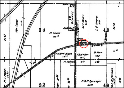
In a series of emails, Rick shared his thoughts and research. He wrote, "A couple of people have left comments on your blog as to the exact location of the Midway Tavern. I would like to know that myself.
"Based on the caption accompanying the old photo, it would seem that the tavern would have been located on either the northeast or northwest corner of route 113. That's based on the caption indicating that the distillery was just north behind the tavern. If, as seems likely, the tavern fronted one of the four corners, the distillery being behind and north of the tavern, would place the tavern on the north side of the road.”
Rick also came up with a map that supports his theory. He wrote,” I found a 1912 plat showing the intersection of routes 58 and 113 at that time. Although the online copy is maddeningly blurry, it would appear that 6 mile house and the distillery were located on the north east side of the intersection. With a little imagination you can almost make out the word “Hotel."
Here is that 1912 map (below).
I also found a map with the word 'hotel' visible as a label for a building on the northeast corner. It dates from 1857 (below). As you can see, there is another hotel further to the east, on the south side of the road.
An 1896 map (below) has no labels, but all of the buildings located at that intersection are clearly on the northeast side of the road.
Note the name "H. Howe" on the map to the east of the intersection. An article about an attempted robbery at the Howe residence in the Elyria Reporter of August 31, 1899 mentioned the tavern. It noted that the victim, Mrs. Jane Howe, and her aged uncle "live near the old tavern on the
telegraph road about six miles west of Elyria."
It does appear that the tavern, then, was located on the northeast corner of what is today the intersection of Ohio Routes 58 and 113.
Here’s a recent view of the intersection.
It does appear that the tavern, then, was located on the northeast corner of what is today the intersection of Ohio Routes 58 and 113.
Here’s a recent view of the intersection.


Huh I would have guessed it was on the NW corner just because of the Spring water available. Enjoyed! Rae
ReplyDeleteHi Rae!
ReplyDeleteYou make a good point! You never know, I've been wrong plenty of times before!
My first thought was spring water as well. Good article.
ReplyDeleteMy first thought was the beer joint that was on that corner in the 60s and 70s, "Nick's".
ReplyDeleteActually, there was a large, old farm house on the north-west corner of the intersection until 3-5 years ago. It was from roughly the same era as the tavern. Since the caption says the tavern burned in the 30's, it must have been on the north-east corner.
ReplyDeleteThere was also another house on the south-east corner, of roughly the same vintage. It was moved a bit south at some point (when 58 was widened?). It was torn down in the 80's.
The 6 Mile House tavern was in fact located on the northeast corner. We all have to remember all the roads were much less wide, so it definitely alters one's perspective as to how the area looks today. Then just east of the Tavern was the Reuben Allen house, built in the 1820s, which was demolished only a few years ago. Behind the Tavern, to the north, was the Crandall Cemetery and also the Whiskeyville one-room schoolhouse. It was quite the bustling place at one time.
ReplyDeleteHi, Where you said "imagine HOTEL" and it is circled, are you sure it doesn't say xxx Cemetery Association? That's what I'm seeing.
ReplyDeleteI was searching for some history on Cherry Knoll Spring and I came across this article while looking. My Father grew up on the Northeast corner of 58 and 113. My Grandparents did have a bar there, Nick and Martha Abraham. We have owned the Cherry Knoll spring since 1983. Cool Article. I had always heard that the spring was used to make Whiskey in this area.
ReplyDelete