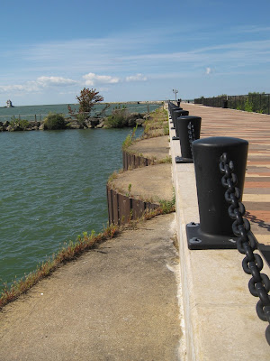
As I walked, I remembered decades ago how it used to be a long, lonely walk out to the end of the pier. Once you got to the end, you might see a couple of other hardy souls and a few fishermen.
Now, with the addition of the access road and parking lot on the Diked Disposal side, you can drive three quarters of the way there – making it much more accessible to the public.
It’s interesting to see how the original cement walkway surface has been enhanced and beautified. I was pretty impressed.
The only thing missing from the sunny scene were a few vendors. A hot dog cart would have been great, and maybe someone selling hot coffee or other beverages. Or maybe a food truck in the parking lot. Then you have a festive, touristy atmosphere that would make Lorain seem more like it's part of Vacationland – instead of a well-kept secret.


Now, my grandfather always took me to that pier and referred to it as the mile long pier. Everyone else I know refers to it as the mile long pier. But its not a mile long...was that just some smartass name given to it because it felt like a mile after walking with all your tackle?
ReplyDeleteWe need someone to get out there with a pedometer and bust that myth once and for all.
ReplyDeleteUsing a mapping tool I get 2300 feet, only .44 mile. That is the part that is over water. Even Google maps calls it the Mile Long Pier.
ReplyDeleteHa! I did the same thing, Dennis and I only came up with 2200 feet. Maybe they were counting both sides of the pier, or the fact that you had to walk back after walking out there?!!
ReplyDeleteAre you guys measuring all the way in to the bottom of the hill behind jackelope?
ReplyDeleteIn talking with my mother, she claims that the mile long that we know may possibly be mistaken for another pier. At some point they changed the names of the streets on the west side. Is there any chance they were numbered instead of states at some point in the east side? I vaguely recall the "mile long" being referenced as possibly the e9th or e6th pier. Or I'm mis-gathering random memories.
My grandfather was born in lorain in '23, I regretfully didn't pay much attention to the things I wish I would have,this was something he probably explained to me a dozen times while hiking out there.
I was thinking of east pier, its other name.
ReplyDeleteI'm trying to find any type of correlation to a mile from the vicinity of that pier.
I wonder if Lorain's "Mile Long Pier" was so named because Huron has its own same-named pier. Chicago's Navy Pier has also been referred to as a mile long pier (even though it isn't). So maybe it is a "me too" status thing.
ReplyDelete