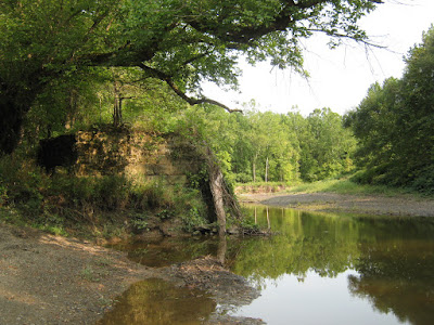
It’s a bit of a hike to get to the abandoned bridge abutments nestled in the Bacon Woods.
Starting where the new Great Nest reproduction is located, you have to follow the Bacon Woods Trail (red markers), then the Bluebird Meadow trail (blue markers), and finally the Coopers Hollow Trail (yellow markers).
But if you keep bearing left and follow the trail closest to the Vermilion River, you can’t miss the abutments. At one point, you will see the one on the one on the west bank of the river peeking through the trees, and a little path leading to it.
If you follow the narrow path towards the river, you will see the abutment on the east bank immediately on your left.
Stepping out onto the river bank, you can get a better look at it.It looks a little nicer in the late afternoon.
And let’s not forget the one on the west bank of the river. Here are morning and late afternoon shots of it as well.
Lastly, here’s a Google Maps view showing roughly where the west abutment is located. You can’t really see it, but I know that’s the approximate location because of the appearance of the riverbank opposite it. I tromped around it a few times in preparation for this post.If I hadn’t dropped out of the Cub Scouts, today I might be able to identify some of the tracks left there by the wildlife (below). Oh well.


The suspense is killing me Dan.What happened to the bridge?Did aliens from another world visit the Coopers and steal it from them?Did it crumble until it fell apart?Did it get blown up during the cold war by the Russians?What happened to it?We all want to know.
ReplyDeleteDan. Google the. “Old Peasly rd bridge. You can do a blog on that area also......... Bill N
ReplyDeleteThose tracks certainly look like raccoon to me.
ReplyDeleteI agree with Drew. We used to see those abutments when were out hiking and camping, but we never knew what they were.
ReplyDeleteHaving grown up on Kolbe Road not far from Cooper Foster Park Road, I was always intrigued by the name. Many roads are named for early settlers whose farms were served by the roads, so I always assumed that Cooper Foster Park Road was named for three early settlers whose land the road intersected, but no one I asked could tell me who these families were. Apparently the Cooper portion of the name was derived from the Cooper family who lived near the western terminus of the road south of Vermilion -- Now who are the Foster and Park portion of the road named after? Does anyone know?
ReplyDeleteHi Rick,
ReplyDeleteThat’s a good question. On the 1896 Amherst Township map, I see that there were some Fosters that owned land at the eastern end of the road, right where Oberlin Avenue runs into Cooper Foster Park Road. Maybe someone from the Amherst historical group can enlighten us as to how the road’s full name evolved.
Darn you Dan... you beat me by a few minutes. For you others. Google. Us1609653,,, and look at the top of the map. Now on to find the Parks.. or was there a real park? Bill N
ReplyDeleteSo maybe I missed it but,what happened to the bridge?
ReplyDeleteI’m still trying to research it and establish a timeline. The road leading to it was abandoned and the bridge appears to have lasted until the mid-1960s. But so far I can’t find any newspaper article about it being demolished or lost in a flood, etc. I’ll keep trying and will reach out to the County Engineer office.
ReplyDeleteit looks as though some engineering was used in the construction of this forgone bridge, not a homemade type of structure. Was down day there wondering about it today. Thanks for giving info even if sparse. Cannot find any other info this is the source.
ReplyDelete