
If you're like me, it's probably been a while – about two cars ago. I remember having to buy a map at a gas station while getting lost in a Cleveland suburb. And the map (which wasn't cheap) was something put out by Rand McNally or somebody – not the oil company.
Since then, like everyone else, I rely on my car's navigation system or use Google Maps directions on my iPhone through Bluetooth. (I have handwritten directions just in case something goes wrong.)
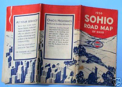
But back in 1930, road maps were essential on a trip. The federal highway system was still in its infancy and many roads weren't paved, and were merely gravel – or worse. You had to have a map.
Thus ads with the promise of a free map, like the one at the top of this post which appeared in the Lorain Journal on May 1, 1930, no doubt lured a lot of drivers to their local Sohio station.
Here's a color version of the map shown in the ad.


My sweetheart and I use paper maps all the time on our cemetery tours, but none of them are Sohio's. We prefer the ones from the Commercial Survey Company with the orange and yellow covers, when they're available. They are old and out of date, but we supplement them with the GPS in my 10-year-old car which itself is somewhat old and sometimes out of date. Sometimes county websites provide their own maps. Sometimes she has to stitch together county maps from townships.
ReplyDeleteFor decades I drove with a (very expensive and increasingly old) U.S. Book Atlas from Rand McNally under the passenger seat. Now, even with a GPS that's a decade old, I don't need it anymore. I made sure both our kids could read maps, in case of a 'pocolypse. Gotta know which is the best way to run to get away from the zombies, y'know!
I worked in several gas stations when I was a young 'un, and I could not understand how we could afford to give away those expensive products. Even back then, there wasn't much margin on selling gasoline.
ReplyDeleteAnyway, thanks for this post, Dan - I love old maps.
Glad you like them, Buster! The ones on the post were all on eBay yesterday.
DeleteI still have my complete US road atlas from State Farm Insurance. You could get a new one every year. But like Don, I love those Commercial Survey map booklets. I have used them for numerous historical searches. My favorite map is a page from the Cleveland Auditor's office that has my current home in North Olmsted on it. The map is from 1927 when the house was 2 years old. Those auditor's maps were updated by hand and mine has several changes pasted over the original print. It also shows a huge subdivision that never actually got built.
ReplyDeleteThe Cuyahoga County parcel numbering system is so easy to use compared to Lorain County's. It is 3 groups of numbers: 123 - 45 - 678. They correspond to Book, Page, Parcel. You go to the Auditor's office, grab the right book, open to the correct page and there is your property.
Don't ask me to describe the Lorain County system!
The auditors all over the state might be out of a job if the state property tax is repealed.Why would they update anything when they aren't able to put a tax it?People just got a little too greedy for their own good.People are willing to pay reasonably,but the current reassements are out of touch with reality.Power to the people!
DeleteI still pick up road maps at various states welcome centers if available.
Delete