Tuesday, June 30, 2020

Tornado Damaged Fifth and Hamilton – Then & Now

I thought I had done every possible "Then & Now" photo of homes damaged by the 1924 Lorain Tornado, but every so often I come up with another one.

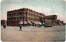
The postcard view above is of West Fifth Street (east of Oberlin Avenue), looking towards Hamilton Avenue (barely visible at the far right of the photo).

And here’s the recent “now" view.

As a bonus, here’s a Google Maps street view circa July 2019 (below). Gee, those lawns look parched.

With so many of the homes in the 1924 view having been torn down, it’s not much of a Then & Now. It’s more of a lesson in how the tornado changed the look of Lorain’s streets forever by eliminating so many of what now be century homes. 
However, the one house in both views is the beautiful, historic one at 440 Hamilton (below). Here are two recent shots.
Local historian Loraine Ritchey has featured this home on her blog, noting that it was built for the well-known Wickens family of Lorain.

Monday, June 29, 2020

1924 Lorain Tornado Headlines in Other Cities

Yesterday was the 96th Anniversary of the 1924 Lorain Tornado.

It’s hard to believe that in only four years, a hundred years will have passed since the disaster that still defines the city.

My parents had told my siblings and me about the tornado when we were very young. Knowing that it had killed so many people, and done so much destruction in the city that we lived, caused me to worry every time there was a tornado watch in effect. My parents must have felt the same way, because we went down in the basement a few times when the sky looked particularly threatening.

Anyway, the infamous tornado has been discussed here on the blog many times.

I posted Jack LaVriha’s look back at the tornado from a 1958 perspective here; a view of the tornado from a 1969 perspective here; then-and-now photos of tornado-damaged houses and buildings hereherehere, here, here, here and here; vintage articles and postcards on the occasion of the 90th anniversary back in 2014 here; and actual front pages of the Lorain Times-Herald and Chronicle-Telegram here.

Just about the only thing I haven’t posted are front pages of how the tornado was covered in a few major newspapers – so that’s what I’m doing today.

Here’s the story as it appeared on the front page of the Philadelphia Inquirer of Monday, June 30, 1924.

“Maimed, desperate, bruised almost senseless, Lorain, a city once of some 50,000 souls, is still trying to count its dead tonight,” the lead article notes.

“Lorain is in ruins. By day, workers attempt to clear away the wreckage. At night, the city is in darkness.

“Martial law has been declared and a thousand troops of the Ohio National Guard, Naval Reserves, the extra police from Cleveland, thirty miles to the east, and from Elyria, ten miles to the south, are keeping order.”

Over on the west coast, the Los Angeles Times took a more regional overview of the storms, including reports of the death toll in Pennsylvania, Iowa and Illinois.

Although the second page headline – “Ghouls Prowl Amid Corpses in City Stunned by Deadly Hurricane” – makes the disaster sound more like a zombie apocalypse, the paper’s coverage is still thorough and impressive.

Friday, June 26, 2020

Powdermaker Road

You can see Powdermaker/Chester Road just above the dotted line
of the proposed route for  I-90 in this 1960s-era map
While looking at old maps in preparation for yesterday’s post about Route 83, I happened to notice the name ‘Powdermaker Road’ for part of what we know today as Chester Road in Avon. It reminded me of something I read in the Chronicle-Telegram a few years ago that made me aware of how easy it is for local history to be forgotten.

The article was about how the planning of the new development along Chester Road was bringing to light some of the old legal descriptions of the properties. This resulted in the name ‘Powdermaker Road’ being discussed, and curiosity as to where the name came from.

What was somewhat surprising was that someone quoted in the article noted that the name came from the fact that back in the day when it was just a dirt road, it was often quite dry – and kicked up a lot of powder when traveled on.

While that may certainly be true, a look at some historic maps reveals that the name more likely came from the fact that the P. Powdermaker (also spelled ‘Poudermacher’) farm was located on today’s Chester Road a little east of the intersection with Moore Road.

Here’s part of an 1874 Avon Township map showing the Powdermaker property.

And here’s a portion of an 1896 Avon Township map.

On that same map you can see the beginning of the Powdermaker Ditch as it makes its march to the lake, just north of the Powdermaker property.

I understand that these various ditches (now referred to as creeks) were dug for drainage purposes.

By the time of the 1912 maps series, the Powdermaker name was no longer associated with the farm properties, and today Chester Road seems to be the name of the road from end to end.

A glance at a map, however, shows Powdermaker Creek (or Ditch) running parallel and just to the west of Moore Road. Where it crosses Pin Oak Parkway, there are still identifying signs.

Today, the Powdermaker name also lives on in the attractive Village at Powdermaker Creek residential development, which is adjacent to its namesake creek.

Thursday, June 25, 2020

Ode to a Road: State Route 83

Today’s blog post was written by longtime contributor and local historian Dennis Thompson. Dennis wrote it as a response to my story a few weeks ago about Klatik’s Log Cabin and its location on State Route 83.  As Dennis explains, the road has been known by different names and numbers over the years, and it came very close to losing its current '83 designation to a replacement highway. 

****

The Saga of Center Road and Route 83
By Dennis Thompson

If you read the comments on Dan’s blog article about Klatik’s Log Cabin Nite Club, you will see Rick Kurish's mention of several names for what we now know as Route 83. As is typical of many of the area main roads, it started out as a descriptive name – Avon Belden Road.

As these roads went through villages, they often got renamed within the village limits. In this case, both Avon and North Ridgeville used Center Road as the local name for Avon Belden Road.

Ohio’s major roads got numbered within the state highway system in the early 1930s and Avon Belden Road was then known as State Route 76. This can be a bit confusing if you read old phone directories or newspaper articles, or look at old maps. 
Skip forward a few decades to the time of the Interstate Highway system and we see that Interstate 76 is scheduled to be built in Ohio. 


So, in 1972 the state renumbered State Route 76 as State Route 83 to avoid confusion.
When the federal highway system was being planned, state and county officials realized there was no major state highway that ran north and south in the area. We drive on Routes 57, 58, 83, 301 and 511 to go that direction. But these are two lane rural highways that go through every village they encounter.  So they decided to add a four lane highway that was limited access as needed. They choose the recently renumbered State Route 83. 

Period maps show the proposed path would be to the west of Avon Belden Road. The new highway would be State Route 83 and the old road would be just Avon Belden Road with no state numeration.

This was a part of the grand plan that added Interstates 80 and 90, and modernized State Routes 2 and 10, as well as U. S. 20 in the county. Since the plans for Routes 10 and 20 were ready to start construction, the officials decided to begin building State Route 83 where it crossed State Route 10. This would avoid a later construction that would impede traffic on Route 10. And indeed - they built that section.

This Google Maps view shows the result – a half mile stretch of road with an interchange onto State Route 10. That is why when you exit State Route 10 you are on a roughly north-south country road instead of State Route 83. That short road is designated “Alternate State Route 83” or “State Route 83C”.  Alternate State Route 83 includes the section of Butternut Ridge Road (Lorain Road) that leads back to Avon Belden Road. 


And they did it again at State Route 2. This Google view shows the short stretch of State Route 83 that is to the west of old Center Road. There are two dead end sections of old Center Road remaining. In this case the newly created State Route 83 does have a name – Center Road. This westward jog and the turn back to the east on Chester Road creates headaches every single day.

That is all that was ever built of the State Route 83 highway scheme. The project was abandoned in 1991. 

Thus we still have to drive south on rural roads.  The proposed Route 83 would be forgotten, except for the fact that it made it onto some maps. These (below) are from the 1976 Commercial Survey, Lorain County Street Guide. (The never-built proposed relocation of State Route 83 is indicated in yellow.)

Although it would have been nice to have a high speed north south corridor, I hate to think of how many Lorain County farms would have been cut in half for the new highway.
I will end with some more trivia about Avon Belden Road. I could not find a reference to when the road was first built. It seems to be complete through the county on the 1851 plat maps. It is a bit hard to tell as the road coincided with property lines. But it could not have been the Avon Belden Road in 1851 as there was no Belden yet.  Belden was originally called Rawsonville. The name was changed to Belden in 1876. It is named after Bildad Beldin, a pioneer settler. (To learn more about the early days of Grafton and Rawsonville, click here.)

State Route 83 goes all the way to Beverly, Ohio in Washington County. There it ends near a BP station on State Route 60 a couple hundred yards short of having to cross the Muskingham River. It is 157.6 miles long.

In the 1976 maps, note that it is called the Avon Lake-Wooster Road starting in North Ridgeville. I can’t recall anyone using that name but Google uses it also. 

After it leaves Wooster, it is called the Millersburg Road. South of Millersburg it does not seem to have a name.

And finally, Route 83 isn’t the only state highway for which big plans were made that never got past the drawing board stage. As part of the big highway scheme, State Route 18 was proposed to have been made into a four lane highway with a bypass around Wellington. Today, parts of State Route 18 have been widened to 4 lanes but only east of Medina – not in Lorain County.


The northern terminus of State Route 83 at Veterans Park in Avon Lake.

Wednesday, June 24, 2020

The Scoop on the Loop – Part 2

Vintage postcard circa 1907
Apparently, getting rid of the Loop had been talked about for a while. After all, it was dangerous to have streetcars turning around in one of the main intersections of the business district.

This article from the Elyria Republican of August 9, 1907 mentions the removal of the Loop as one of the proposed improvements to be undertaken by the streetcar company.

But it was not until 1919 that the removal of the Loop actually happened. This article on the front page of the April 4, 1919 Lorain Times-Herald noted that track removal would be starting soon.
 And on June 12, 1919, this article on the front page of the Lorain Times-Herald noted the historical significance of what was happening.
The article observed, “For a quarter of a century the loop at Broadway and Erie-av has been the city’s principal storm center. It has caused political quarrels and score of franchise controversies.
“This morning a gang of workmen began tearing up the rails of the loop and it is no more. Cars are being run to West Erie-av and are being turned on the Y near the interurban station. 
“Before many hours all that will be left of the loop will be the trolley wires over heard and they will soon come down. A Y at the intersection of the streets will replace the loop and cars will be run to a new loop in north Broadway.”
The passing of the Loop even made the pages of the Elyria Evening-Telegram on June 13, 1919.
****
Although its tracks have been gone for more than a hundred years, the Loop lives on in the memories and vernacular of longtime Lorain residents and local historians.

It will be interesting to see if newer residents of the city perpetuate this nickname. Or is it already dead?

Perhaps some savvy restaurant owner at or near that intersection will revive the name.

****
I did a Then & Now post on the Loop back in 2016 here, with some of the same postcards, but without the historical perspective. 

Tuesday, June 23, 2020

The Scoop on the Loop – Part 1

The Loop, circa 1905
If you grew up in Lorain like me, then you undoubtedly heard your parents refer to the intersection of Broadway and West Erie as the Loop.

I don’t recall my parents explaining why they called it that. They just did.

It wasn’t until I learned a little local history that I got an explanation. It was called the Loop because that’s where the northbound streetcars used to turn around via a big loop in the tracks before heading south on Broadway again.

It’s kind of neat to see vintage postcards of the actual Loop itself, with the tracks forming a big circle right in the middle of the intersection. The postcard at the top of this post was postmarked 1905.

And here’s one in color (below), circa 1907. (It’s actually the same composition as the 1905 view, only with color added, and with the ugly wires and poles retouched out.)

And this (below) is a slightly tighter view, circa 1910.

And here's a view circa 1911.

So why am I bringing this up now? Because it was back in June 1919 that the streetcar tracks for the original Loop were removed. And it was quite a historic occasion.

How did it play out in the newspapers? To stay in the loop, stop back here tomorrow!

Monday, June 22, 2020

1970 Vermilion Festival of the Fish: Wrap Up

The Vermilion Photojournal of June 25, 1970 had a wrap-up of the Fourth Annual Festival of the Fish. As I noted a few days ago, unfortunately the Sunday parade was rained out.

The front page featured yet another nice photo of Festival Queen Linda Vasitas. There’s also a nice photo of one of the Nolan Carnival rides, the “Round-Up.”

The photo caption of the band concert needs one correction, though: the American Federation of Musicians chapter in Lorain was Local 146. I know, because I was a member of it in the 1980s. (Sooner or later, some of my reminisces from those musical days will make it onto the blog.)

I read in the Photojournal a few days ago that there’ll be no Festival of the Fish this year due to the Coronavirus and that’s a shame. I like a festival where a fish is guest of honor because he's tasty – not something to set on fire.

Friday, June 19, 2020

1970 Vermilion Festival of the Fish: Nolan Shows Carnival

Here’s a nice full-page ad for the Nolan Shows carnival featured at the 1970 Vermilion Festival of the Fish, which ran June 19 through the 21st – 50 years ago. The ad ran in the Vermilion Photojournal on June 11, 1970.

The carnival, set up at the shopping center, had a two-day jump on the festival itself.

I like posting ads for carnivals and circuses. Their old employees often go online to locate co-workers and reminisce about the owners and performers. I’ve written about the Cristiani-Wallace Circus, the Adam Forepaugh and Sells Brothers Circus, and the Paul A. Miller Circus (that our friend Bill Nahm remembers so well).

As the ad notes, Nolan Shows operated out of Zanesville with two units traveling independently of each other.

And here’s a great profile of the man behind Nolan Shows: Fred A. Nolan. The article appeared in the Zanesville Times-Recorder on Sunday, August 21, 1966, and sheds some light on the life of a "carny.”

Next: More 1970 Vermilion Festival of the Fish Fun

Thursday, June 18, 2020

1970 Vermilion Festival of the Fish: Cleveland Indians and Royalty

Although the 54th Annual celebration has been postponed due to the Coronavirus, the Fourth Annual Vermilion Festival of the Fish back in 1970 came off as planned (although rain resulted in the cancellation of the Sunday parade). The Festival ran June 19 through the 21st.

Part of the fun back in 1970 was the special appearances of some Cleveland Indians players as part of a promotion sponsored by Lorain National Bank. Above is an ad that ran in the Vermilion Photojournal on June 18, 1970.

That’s quite a lineup of Indians players slated to appear: “Sudden Sam” McDowell; Ken “The Hawk” Harrelson; Ray Fosse; Dean Chance; and Tony Horton.

While I was familiar with some of the other players (my brothers and I had “Hawk” Harrelson autographed photos), I didn’t know the sad story of Tony Horton’s short baseball career until I read his Wiki entry. Here’s hoping he’s doing well today.

Horton did have the honor of posing with the lovely duo of 1970 Festival of the Fish Queen Linda Vasitas and Attendant Debbie Wakefield though.

Photo courtesy Vermilion Photojournal
June 18, 1970
Queen Linda Vasitas and Attendant Debbie Wakefield were also featured in an ad for Erie County Bank that ran in the June 18th Photojournal.

Tomorrow: More 1970 Vermilion Festival of the Fish Fun

Wednesday, June 17, 2020

Fulper’s Sohio Service Ad – June 9, 1970

Here’s a nice full page ad from the June 9, 1965 Vermilion Photojournal for Fulper’s Sohio Service promoting the Vermilion Lions Club fundraising effort.

Gas-o-Rama seems to have been (and may still be) a popular Lions Club promotion all over the world.

I’m assuming Lions Club members manned the pumps at the station that day, with some sort of profit-sharing agreement that would benefit the club. Tickets were also sold in advance for perhaps a fill-up or some service. Anyone know for sure?

Courtesy Ritter Public Library
The Fulper station was located on the southeast corner of West Liberty Avenue (U. S. Route 6) and Grand Street. Rich Tarrant’s Vermilion Views website (here) says that a Standard Oil station at that corner dated back to 1936. If you follow the link, there is also a terrific color photo of the station as it originally looked, before it was expanded to the building seen in the 1970 ad.

At left is a photo of the original station circa 1942, courtesy of the Ritter Public Library website. This link will take you to the Ritter Public Library page with four vintage photos of the station, including one when it sold Dyna-Gard brand gasoline before it closed for good.

Today the corner is empty. A February 12, 2020 Morning Journal article noted that it was recommended to be a new parking lot, and that seems to be the way it's being used now.


Tuesday, June 16, 2020

Vermilion Bandstand Razed – June 1965

Vermilion's old brick bandstand which was located
in Victory Park (Photo Courtesy of Ritter Library)
Local landmarks found in a public park, like statues, monuments and fountains, are a funny thing.

Residents get used to seeing them all their lives. But these iconic structures are man-made, and don’t last forever. Unless they get maintained or rehabilitated, they often get removed.

If the local newspaper didn’t document the removal with an article or photo, the exact date of the landmark’s passing into history is often lost to time.

And that’s why when I do find a nice article about the demolition of an important landmark, I like to post it and get it online for interested parties to find.

Once such landmark was Vemilion’s old bandstand, which was located in Victory Park. The bandstand's demolition was of historical significance, and the Vermilion Photojournal devoted the entire front page of the June 30, 1965 edition to it.

The article provided a history of the structure as well as the surrounding area. It noted, “About 1919, after the New York Central Railroad tracks were raised, closing off Exchange and Toledo streets, and the railroad station remodeled, the brick and stone bandstand was constructed. Commodore F. W. Wakefield is said to have donated the brick which was used in the construction.
“There was a basement with a center cement block wall dividing the basement area. Two outside stepped entrances were provided to the basement.”
One of the photos accompanying the Vermilion Photojournal article shows the basement being filled.
Today the park (located south of the railroad tracks with Main Street as its western border) has an attractive gazebo as its centerpiece.

Monday, June 15, 2020

Beulah Beach

I’ve been driving by Beulah Beach just about all my life and never really knew too much about the place. It’s located about halfway between Vermilion and Huron on West Lake Road (U. S. Route 6).

Here’s what it says in my copy of Lake Erie Vacationland in Ohio - Revisiting a 1941 Travel Guide to the Sandusky Bay Region:

BEULAH BEACH, 6.9 m, is a summer camp (R) and convention site for members of the Christian Missionary Alliance. Cottages and dormitories accommodate students who come here to get training for home and foreign religious work.

For a more up-to-date description, I consulted its Wiki entry. It said that Beulah Beach is an unincorporated community located in the western part of Vermilion Township, and confirmed that it is still true to its roots after all these years.

"Beulah Beach had its start in 1920 as a Christian commune," it notes. "It currently has a summer camp and retreat center, Beulah Beach Camp and Retreat Center, affiliated with the Christian and Missionary Alliance denomination and a member of the Christian Camp and Conference Association.

But can anyone go there?


The Beulah Beach website notes that it is open to families as well, with a variety of programs. "As a ministry of the Christian Missionary Alliance, amid the demand of the frantic pace of today’s world, Beulah Beach Camp and Retreat Center has been a place of rest, relaxation, & spiritual renewal for guests since 1921,” the website states. 
"Open year round and overlooking the beautiful shores of Lake Erie, Beulah Beach offers guests a relaxed and comfortable place to retreat and be revived in body and spirit. We serve groups of all sizes, the location is ideal, the rooms are comfortable, the food is phenomenal, meeting rooms are spacious and well equipped, and we are within minutes of great attractions.”
Its kind of nice to know that the camp has been around as long as it has.
Here are some vintage postcard views.
I’ve only been on the grounds of Beulah Beach once in my life. Back in the 1960s, we bought my pet hamster (Rufus) from a resident there who raised them as a hobby.

Beulah Beach has only been mentioned on this blog once before. Peck’s Cottages (subject of a multi-post series) is now part of the Beulah Beach complex.