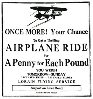
In July 1928, the idea of the City of Lorain having an airport was being promoted, and rapidly gaining in popularity. The original proposal was to lease an airport owned by Bill Long that was located on West Erie Avenue, about a mile west of Lorain.
As this article from the July 24, 1928 Lorain Times-Herald noted, “The plan in mind is to lease 80 acres of land fronting on the Lake-rd a mile west of Leavitt-rd now being used by William Long as a commercial airplane site. Expenses of the airdrome would be defrayed by the taxing of companies using the field for passenger and freight flights.”
This article commended “the site west of Lorain on the Lake-rd, now being used by William Long, as probably the most suitable of any in the vicinity."
I’m not sure what happened, but the plan to lease Bill Long’s airfield never got off the ground. Instead, a new airport – Port Mills – opened on the northeast corner of Meister and Leavitt Roads on July 27, 1929. It was operated by Lorain Airways Service, Inc., headed by Richard W. Mills and his son, Leland, who was the manager of the field. At the time it was said to be “the largest privately owned airport east of Mississippi.”


I live in the Old O'hara house... My kids went exploring in the woods behind the house yesterday... They found bunch of dead deer bones.. They came across a course thats maybe used for hunting or for shooting.. not too sure... But they say they came to an abandoned road back there also.. They said there is real old fire hydrants on that road.. And pieces of metal objects that the trees have grown into.. Could this road be part of the airport?
ReplyDeleteThanks for leaving the comment. That’s pretty interesting about the old bones.
ReplyDeleteAs for the abandoned road, I looked at the Historic Aerials website and entered the location, “W. 21st and Leavitt Rd Lorain 44053.” I think I see the road that your kids located. There is one clearly visible on the 1952 view, it is “L” shaped and extends from W. 21st Street south and then heads east and disappears into an orchard that would be just behind and just south of today’s Burger King. The road seems to run along the property line of a big piece of land fronting on W. 21st and next to the huge woods (even in 1952) that has the water line ‘notch’ near its southern border.
I’ll see if I have a really old map and try to determine what the road was, if I can.