In the above photo, the view is looking west (with the houses in South Lorain on the west side of the river). You can see the old 1913 bridge approach, which is the short road running parallel and to the left of the modern E. 31st Street. It’s the same road being constructed in that vintage photo shown at left, and the same view.
I used to wonder why there was nothing along that stretch of roadway from E. River leading up to the bridge, such as vintage homes or farms. Now that I know that the road was built on top of slag, it makes sense.
Here’s a look at today’s E. 31st Street Bridge – constructed in 1977 – and its approach, looking west from last weekend. The old 1913 approach can be seen at left, although it is snow-covered.
To refresh your memory, here's that vintage photo again of the 1913 bridge.
Here’s another modern aerial view (below) from the opposite direction.
That’s the Lorain County Metro Parks Day’s Dam Black River Reservation at the bottom of the photo.
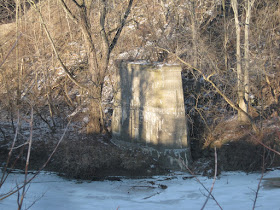
If you click on the aerial photo and look closely, you can see several old trestle supports that are to the south of the old bridge causeway. Here are some shots of them (below) from last Saturday evening.
As explained to me by archivist and historian Dennis Lamont, both trestle supports are from the bridge that carried the old Avon Beach & Southern spur of the Lake Shore Electric Railway over the Black River.
Here’s the view from the Day’s Dam Metro Park on Sunday morning.
Unfortunately, the interesting local history in plain sight – the site of the old 1913 bridge, its modern replacement, the causeway built on slag, and the trestle supports of the street car bridge – is not mentioned on the adjacent Metro Park sign (below).
To be fair, however, some of the history is briefly discussed on the Lorain County Metro Parks website.


Nice. Looking at the photo of the slag approach being built, it seems the same row of houses in the background of the photo is still there today.
ReplyDelete