 |
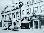
| This illustration of “Suicide Strip” accompanied the article below |
But did you ever hear of the “Suicide Strip” running from Lorain to Vermilion via U. S. Route 6?
I hadn’t either, but it was the subject of the nearly full-page article below, which ran in the Lorain Journal on January 6, 1968. The story is a fascinating look at what it was like to drive on Route 6 west from Leavitt Road to Vermilion, with the emphasis on the dangers that drivers encountered.
You’ll find that some of the same concerns that Jerry Walker wrote about back then are still valid today.
Anyway, the article is kind of long, so I’m busting it into two parts.
****
By JERRY WALKER

It’s not a very long trip – only about 10 miles. But it’s a dangerous trip and you’ll have to be alert every second or you might be another of the strip’s victims.
“Suicide Strip” is actually better known as combined Rts. 6-2 or the Lake Road (West Erie Avenue in Lorain and Liberty Avenue in Vermilion) which runs from SR 58 in Lorain to Main Street in downtown Vermilion.
If you come, you’ll get a “driver’s eye view” of the countless hazards lurking around every bend.
At times the speed limit is 35 miles an hour and changes to 50 miles an hour in spots. But you’ll notice that traffic generally travels from 50 to 70 miles an hour.
So let’s start the motor and take a spin.
It’s Friday night in “teen town.” You’re driving west on combined Rts. 6-2. You pull up to SR 58. The traffic light is red. You stop.
But, as soon as that light turns green, watch out. You’re on “Suicide Strip.”
YOU START TO PULL through the SR 58 intersection, but you don’t go far. You are quickly initiated as you’re stopped dead in your tracks. Looking ahead you see 10 cars waiting to pull into Manners Restaurants on the south side of the road.
There is a green arrow pointing south, but only a few cars take advantage of it. The number of cars waiting to turn does not lessen.
So you wait. Cars are streaming by in the eastbound lanes of the divided highway. Suddenly a car breaks across the highway into Manners with tires squealing.
You change lanes and pull over into the right lane but don’t get far before you are foiled again. Cars are stopped waiting to get into popular McDonald’s Drive-In. Horns blare and tires screech as cars grind to a sudden halt. You wait and wait. You’re becoming impatient and irritated. But somehow you manage to creep through the tangle of machines and zip out to the open highway.
It’s not over yet, there are nearly 100 other businesses on the strip. Just when you think it’s safe, you go into an S-shaped curve.
As you’re coming out of the curve, you notice a sign that says MERGING TRAFFIC. Cars running along SR 611 start to pull into the westbound lane of “Suicide Strip.” Watch out for that truck. Quick, pull over to the left. “Whew.” You made it. The truck squeezed itself onto “Suicide Strip,” narrowly missing you.
Watch out for that car pulling out of Benny Hart’s nightclub and that one pulling into the Roman Villa on the left.
From then on driving is calm and orderly (with exception of the area near Beaver Park in the summer) until you reach Baumhart Road.
Lorain’s Ford Assembly Plant corners the Baumhart Road intersection. A Ford Security Guard said the busy hours for the intersection are presently 12:30 and 6:30 a.m. and 3 and 4 p.m. but the new shift change times after the “change over” will be 5 and 6 a.m. and 5 and 6 p.m. The guard also said that the majority of Elyria and Amherst workers have been using new Rt. 2 which eases the situation a little at the Baumhart intersection.
The first things you notice are the three possible ways to pass through the intersection. One lane moves traffic south to Baumhart. The other two lanes go through the intersection on Rts. 6-2. There are traffic lights for these two lanes, but they’re always “green.”
So you start through the intersection in the left lane of the divided highway.
You look to the left and see Baumhart Road traffic pouring out into the westbound lane – YOUR LANE. Now a car from Baumhart is parallel to you and traveling at speeds up to 50 miles an hour with only a median strip preventing collision.
The BAUMHART ROAD car is quickly merging into your lane. What to do? In seconds your two cars will meet in collision. You slam on the brakes. The Baumhart Road car shoots ahead. You’re safe – this time. But what about next time?
You drive a little farther, past the Steak House and up towards a four lane bridge. But suddenly the four lane road becomes six lanes and a car is merging onto Rts. 6-2 on your right from Overlook Road. You quickly check your rear-view-mirror, and switch over the next lane at left. You missed that car by inches.
Tomorrow: Part 2

4 comments:
Wow! Either January 6,1968 was a slow news day or the writer was doing a tongue-in-cheek parody of the section of Route 58 known as massacre mile. During the 1969 to 1972 time frame I traveled the section of road mentioned in the article virtually every day, many days several times a day, during morning, afternoon rush hour, and evening, and never once either witnessed or participated in any of the hairbreadth escapes mentioned as daily occurrences in the article. All things considered, my journeys were relatively uneventful. Maybe I was just lucky.
If any part of Lorain deserved the title "suicide strip" it would have been Broadway from the loop south to about 21st Street. In the 1950s and 1960s the area was super busy with traffic, on street parking, pedestrians jaywalking across the street, and traffic lights on virtually every corner. Add to that the teens constantly "cruising" Broadway, the incessant beeping of car horns and you have some idea of the multiple hazards. Ahh, the good old days. What the city wouldn't give for their return!
Great comment, Rick!
I’ll bet the reporter would have a field day documenting a drive around Lorain today. The removal of so many traffic lights has created some dangerous intersections, such as East Erie and Root Road.
Also, the Bascule Bridge should probably be nicknamed “Suicide Bridge” now that eastbound traffic has to merge down to one lane before exiting the bridge to accommodate a new bike path. Now, every time I drive the bridge heading east, at least one car recklessly passes everyone on the right and cuts in at the last minute at the east end of the bridge. It would have made more sense (and been a lot safer) to start the bike path at Colorado Ave.
I heard from my grandparents who built their home at the far east end of Cleveland Blvd, and also lived with their parents before that on Lakeview at the turn of the last century, that Erie Rd. used to be super busy when it was a main highway before the other highways went in. And "machines" were very dangerous because there weren't a lot of stop signs or signals or speed limits, and people would get mangled or cut badly because vehicles were built without safely glass and with sharp pieces of metal. Anyways, they would travel the lake road to the east coast and up to Canada in one direction, and people went way out west in the other direction. The passenger rail line used to be right behind their house to the north, and my grandmother said when you walked over that up to Erie at Euclid there used to be signs that said "Yellowstone Highway" because it was the route to Yellowstone Park. Have you ever heard anything about that?
That’s really interesting that your grandparents remembered that U. S. 6 through Lorain (East Erie Avenue and West Erie Ave.) used to be part of the Yellowstone Trail, one of the early “named" transcontinental highways (such as the Lincoln Highway or Roosevelt Highway) that predated the modern numbering system. Occasionally a really old photo of some highway junction surfaces showing the jumble of signs of all of the different privately sponsored roads competing for travelers. It used to be quite a mess until the federal government introduced its numbering system in around 1926 and all the private trail signs came down after that.
Here is a link to a good Yellowstone Trail website:
http://www.yellowstonetrail.org/maps.html
Post a Comment